


Mad Mutt Marine GPS Navigator

Descrizione di Mad Mutt Marine GPS Navigator
I started writing this application as something that would be useful to me. Since that it has grown and I am rather pleased with it. It is an aid to marine navigation and must be used in conjunction with charts that are printed on that white stuff that is called (So I’m told) paper.
Features
•Designed by and for a sailor. You may find that some of the layouts look “big and blobby” at first sight, but they work at sea. Fiddly and fussy layouts do not.
•No network required. This app uses your phone’s GPS, it will work where there is no mobile network coverage (though you will need network coverage to share your logs and waypoints by email).
•Store unlimited waypoints (restricted in free version).
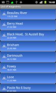
•View waypoints alphabetically of by distance from your current position.
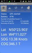
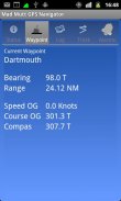
•Display range and bearing to a waypoint.
•Make logs of where you have been, which you can annotate with comments and other relevant data.
•View logs as display on the phone.
•Share logs with Google Earth on your phone or desktop computer, either by email or by copying KML files.
•Share waypoints with Google Earth on your phone or desktop computer, either by email or by copying KML files.
•Share logs with Google Earth on your phone or desktop computer, either by email or by copying KML files. Although I don’t encourage the use of Google Earth for marine navigation, seeing your waypoints on Google Earth is a useful visual check that you have transcribed them correctly.
•Anchor watch alarm service. Alerts you if you have moved more than a pre-defined distance. The anchor watch also alerts you if the battery level is low.
•Near waypoint alarm service
•Once started, the log, anchor and waypoint alarm services will continue to run, even if you quit the main navigator application. They will continue to run while you make phone calls or use your phone for email, Internet browsing or pretty much anything else.
What this application is not
It is not a chart plotter. This application is intended for marine navigation. Although it could be used by ramblers, that isn’t the main intention. It does not display digitised charts, nor does it show you a Google Map view with your position displayed on it. I believe it is highly irresponsible to encourage the use of Google maps to navigate boats. Even in rivers and estuaries, Google maps contain no semantics for the sea whatsoever; no lights and marks, depths, rocks etc. The application does allow you to send logs you have made to Google Maps, though, but only after you have completed the trip.
Free Version
For a limited time, a free version is available. In the Autumn of 2012 a full feature version should be available.
The free version has the following limitations:
•The number of waypoints you can have is restricted to 20.
•Routes are not availableHo iniziato a scrivere questa applicazione come qualcosa che sarebbe utile per me. Dal momento che è cresciuta e sono piuttosto soddisfatto. Si tratta di un aiuto alla navigazione marina e deve essere utilizzato in combinazione con i grafici che vengono stampati su quella roba bianca che si chiama (così mi hanno detto) della carta.
Lineamenti
• Progettato da e per un marinaio. Potreste scoprire che alcuni dei layout di guardare "grande e blobby" a prima vista, ma che lavorano in mare. Layout laborioso e pignola non lo fanno.
• Nessuna rete necessaria. Questa applicazione utilizza il GPS del telefono, funziona dove non c'è copertura di rete mobile (anche se sarà necessario la copertura di rete per condividere i propri registri e waypoint tramite e-mail).
• Conservare waypoints illimitati (ristrette in versione gratuita).
• visualizzare i waypoint in ordine alfabetico di base alla distanza dalla posizione corrente.
• Campo di visualizzazione e rilevamento al waypoint.
• Rendere tronchi di dove siete stati, che si possono annotare con commenti e altri dati rilevanti.
• Visualizza i log come display del telefono.
• registri Condividi con Google Earth sul tuo cellulare o computer desktop, sia per posta elettronica o per la copia di file KML.
• Condividere i waypoint con Google Earth sul tuo cellulare o computer desktop, sia per posta elettronica o per la copia di file KML.
• registri Condividi con Google Earth sul tuo cellulare o computer desktop, sia per posta elettronica o per la copia di file KML. Anche se non incoraggiare l'uso di Google Earth per la navigazione marina, vedendo i vostri waypoint su Google Earth è un controllo visivo utile che li hai trascritto correttamente.
• servizio di allarme orologio Anchor. Avvisa se si è spostato più di una distanza pre-definita. L'orologio di ancoraggio anche avvisa se il livello della batteria è basso.
• servizio di allarme Vicino waypoint
• Una volta avviato, il registro, ancora e servizi di allarme waypoint continueranno a funzionare, anche se si chiude l'applicazione di navigazione principale. Essi continueranno a correre mentre si effettua una chiamata o utilizzare il telefono per la posta elettronica, navigazione Internet o qualsiasi altra cosa.
Nei questa applicazione non è
Non è un plotter. Questa applicazione è destinata navigazione marina. Anche se potrebbe essere utilizzato da escursionisti, che non è l'intenzione principale. Esso non visualizza i grafici digitalizzati, né vi mostrerà una vista di Google Map con la posizione visualizzata su di esso. Credo che sia estremamente irresponsabile incoraggiare l'uso di Google Maps per navigare barche. Anche nei fiumi ed estuari, le mappe di Google non contengono semantica per il mare di sorta; luci e segni, profondità, rocce, ecc L'applicazione non consentono di inviare i log che avete fatto a Google Maps, però, ma solo dopo aver completato il viaggio.
Free Version
Per un tempo limitato, una versione gratuita è disponibile. Nell'autunno del 2012 una versione completa funzionalità dovrebbe essere disponibile.
La versione gratuita ha le seguenti limitazioni:
• Il numero di waypoint si può avere è limitato a 20.
• Percorsi non sono disponibili
Mad Mutt Marine GPS Navigator - Versione 1.07
(04-08-2014)
Mad Mutt Marine GPS Navigator - Informazioni APK
Versione APK: 1.07Pacchetto: uk.ac.plymouth.madmutt.gpsnavigatorUltima versione di Mad Mutt Marine GPS Navigator
Altre versioni


App nella stessa categoria

Potrebbe piacerti anche...


